


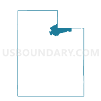
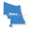
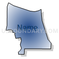
Ranch Place Voting District, Summit County, Utah
About
Outline

Summary
| Unique Area Identifier | 679983 |
| Name | Ranch Place Voting District |
| County | Summit County |
| State | Utah |
| Area (square miles) | 2.67 |
| Land Area (square miles) | 2.67 |
| Water Area (square miles) | 0.00 |
| % of Land Area | 100.00 |
| % of Water Area | 0.00 |
| Latitude of the Internal Point | 40.71074240 |
| Longtitude of the Internal Point | -111.52731060 |
Maps


Graphs
Select a template below for downloading or customizing gragh for Ranch Place Voting District, Summit County, Utah


Neighbors
Neighoring Voting District (by Name) Neighboring Voting District on the Map
- Bitner Voting District, Summit County, UT
- Highland Estates East Voting District, Summit County, UT
- Highland Estates West Voting District, Summit County, UT
- Park West Voting District, Summit County, UT
- Ranch Road South Voting District, Summit County, UT
- Silver Creek Voting District, Summit County, UT
- Silver Springs Voting District, Summit County, UT
- Snyder's Mill Voting District, Summit County, UT
Top 10 Neighboring County Subdivision (by Population) Neighboring County Subdivision on the Map
Top 10 Neighboring Place (by Population) Neighboring Place on the Map
Top 10 Neighboring Unified School District (by Population) Neighboring Unified School District on the Map
Top 10 Neighboring State Legislative District Lower Chamber (by Population) Neighboring State Legislative District Lower Chamber on the Map
Top 10 Neighboring State Legislative District Upper Chamber (by Population) Neighboring State Legislative District Upper Chamber on the Map
Top 10 Neighboring 111th Congressional District (by Population) Neighboring 111th Congressional District on the Map
Top 10 Neighboring Census Tract (by Population) Neighboring Census Tract on the Map
- Census Tract 9643.07, Summit County, UT (4,916)
- Census Tract 9643.08, Summit County, UT (2,960)
- Census Tract 9643.06, Summit County, UT (2,593)
- Census Tract 9643.05, Summit County, UT (1,526)